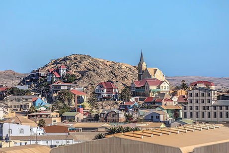
The beautiful town of Lüderitz is situated approximately 684km form the Capital city of Namibia, Windhoek. it became the first German settlement in South West Africa, now known as Namibia. Franz Adolf Lüderitz (a German settler), began trading operations and persuaded the German government in 1883 to place the territory under German protection. Lüderitz is a fascinating old German town, full of character. There is only one road to Lüderitz, and bulldozers battle to keep it open through the shifting sands of the Namib Desert. Local Namibians say that Lüderitz can have all four seasons in a day, as the weather can change in hours from bright, hot and sunny, to strong winds, to dark, cold and foggy – and then back to sunshine again. In 1908, during construction of a railway, diamonds were discovered in the Namib desert. Through this discovery, Lüderitz became a very successful mining town.The Sperrgebiet area, where no one may enter without permit, for diamond mining was strictly controlled. The Sperrgebiet, which literally translates as ‘the forbidden zone’, covers an enormous 26,000km² (20% larger than Wales!). It protects endless desert plains, treacherous shifting sands and the secrets of ghost towns, abandoned relics of communities that sprang up at the turn of the century, fuelled by a diamond-rush.
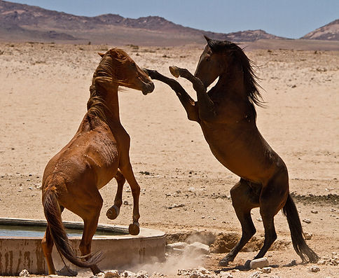
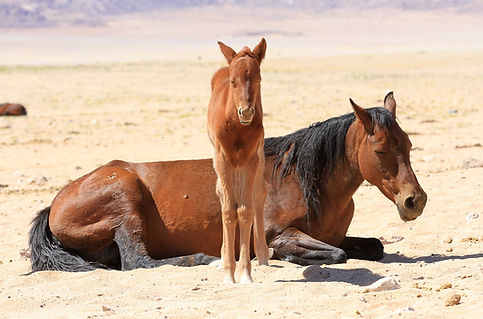
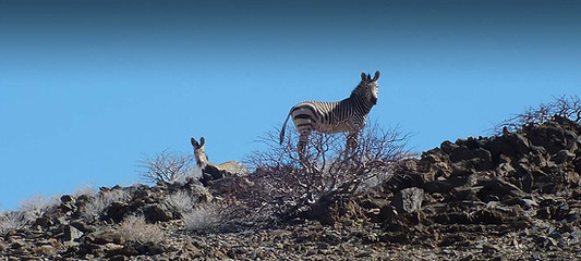
Desert horses
On the edge of the Koichab Pan, around Garub, perhaps the world’s only desert-dwelling horses are thriving. On average, the numbers fluctuate between 90 and 300at any one time, depending on the annual rainfall. The number of the desert horseschanges over the years, there are approximately 200 horses now. Their origins havefuelled considerable controversy over the years. Some considered that they were descended from farm animals that had escaped, or horses that the German Schutztruppe abandoned at the start of World War I.
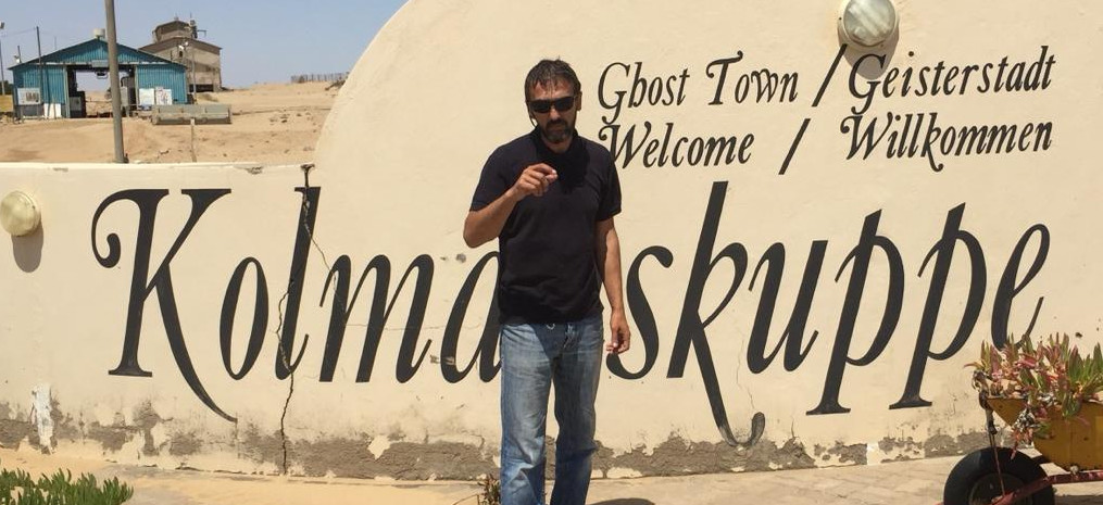
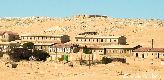
Kolmaskop
This is a (now) ghost town situated in the Namib desert in southern Namibia, 10 kilometres inland from the port town of Lüderitz. It was abandoned over 45 years ago and now gives a fascinating insight into the area’s great diamond boom. A few of the buildings, including the imposing concert hall, have been restored, but many are left exactly as they were deserted, and now the surrounding dunes are gradually burying them. Once the richest town in Namibia, now one of the emptiest know, the town was abandoned once there were no longer any diamonds to be found in the area. Today Kolmanskop sits in a restricted zone controlled by the Namdeb Diamond Corporation, a joint venture owned by De Beers and the Namibian government. With the right permit, people are welcome to visit. Kolmanskop is named after an ox-cart driver called Johnny Coleman, who abandoned his wagon near the site during a sandstorm. In April 1908, Zacharias Lewala, a Namibian worker on the railway line between Luderitz and Aus, picked up a shiny stone and showed it to his supervisor, August Stauch. Lewala was was the first person to discover a diamond in Namibia. Within months the diamond rush was on around the siteof Kolmanskop. Virtually everybody who could rushed into the desert to look for diamonds. Famously, in some places they could be picked up by the handful in the moonlight. In 1912 Kolmanskop produced one million carats of diamonds – nearly 12% of the world’s total. By the 1930s the town’s riches were largely depleted. When diamond deposits were found 270km (168 miles) to the south, close to Namibia’s border with South Africa, many of Kolmanskop’s miners moved on.
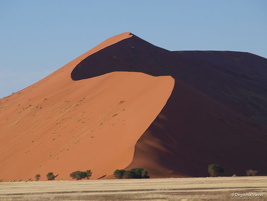
Dune 45
The dunes of the Namib Desert were created by sand carried by the wind from the coast of Namibia. The sand here is 5 million years old and is red in color due to its iron oxide content. As the lighting changes with the time of day, so does the appearance of the dunes’ characteristic color, allowing for interesting photographs at any time. The wind in the Sossusvlei area blows from all directions, which means that the type of the dunes hare are known as “star dunes”. This is because the winds cause the sand to form a star shape with multiple arms. The Dune is 85 meters high and the climb is well worth the effort as from the top you will be spoilt with the incredible panoramic view of Dune Valley. Dune 45 is named for its proximity to Sesrium Gate. It is situated 45km from the gate, along a paved road and is easily reached using a 2×4 vehicle. Its fascinating shape and accessibility makes it the most photographed dune in the world.
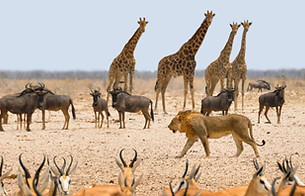
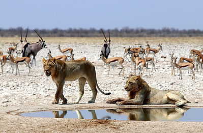
Etosha National Park
The park’s main characteristic is a salt pan so large it can be seen from space. Yet there is abundant wildlife that congregates around the waterholes, giving you almost guaranteed game sightings. A national park in northwestern Namibia and one of the largest national parks in Africa. It was proclaimed a game reserve in March 1907 in Ordinance 88 by the Governor of German South West Africa, Friedrich von Lindequist. It was designated as Wildschutzgebiet in 1958, and was elevated to the status of a national park in 1967 by an act of parliament of the Republic of South Africa. The Etosha Ecological Institute was formally opened on 1 April 1974 by Adolf Brinkmann of the South-West African Administration. The institute is responsible for all management-related research in the park. Classification of vegetation, population and ecological studies on wildebeest, elephants and lions, and studies on anthrax were among the first major topics to be investigated.
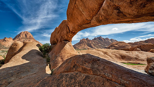
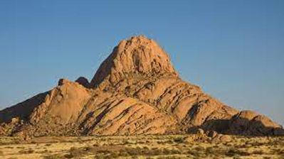
Spitzkoppe
Is a group of bald granite peaks or inselbergs located between Usakos and Swakopmund in the Namib desert of Namibia. The granite is more than 120 million years old and the highest outcrop rises about 1,728 meters (5,669 ft) above sea level. The peaks stand out dramatically from the flat surrounding plains. The highest peak is about 670 m (2,200 ft) above the floor of the desert below. Any ascent of the peak involves exposed and delicate rock climbing of a high grade. While the standard route up the peak is not severely difficult in modern technical terms, it presented quite a formidable undertaking in the earliest days, owing to the isolation of the peak, the heat of the desert and the total lack of water.
Damara Land
In the 1970s the name Damaraland was revived for a Bantustan in South West Africa (now Namibia), intended by the apartheid government to be a self-governing homeland for the Damara people. A centrally administered local government was created in 1980. The Bantustan Damaraland was situated on the western edge of the territory that had been known as Damaraland in the 19th century.